The genesis of StreamNet was the call for standardized information to support the Columbia River Basin Fish and Wildlife Program and 1983 Northwest Conservation and Electric Power Plan Hydro Assessment Study to document the health and energy potential of the Basin's rivers. At the same time, when StreamNet began in 1983 it was intended to be the region's Rivers Information System.
About StreamNet


The HAS was a cooperative regional effort to assess the significance of the region's rivers in a standardized fashion.
The HAS consisted of three distinct, coordinated efforts: the Pacific Northwest Hydropower Database and Analysis System; the region's first anadromous fish data system called the Coordinated Information System; and an inventory and analysis on the remaining environmental categories, called the Pacific Northwest Rivers Study.
One of the primary uses of the PNRS was the designation of over 40,000 miles of streams in the Columbia Basin and adjoining areas as "Protected Areas" from new hydroelectricity development under the Northwest Power and Conservation Council's Columbia River Basin Fish and Wildlife Program. The designation considered resident fish, wildlife, cultural features, natural features, recreation, stream protection, and hydropower development or potential. This protection remains in place today.
The Pacific Northwest Rivers Study was renamed the NED in 1988. As the NED project matured, the geographic scope of the NED expanded from the Columbia River Basin to include Washington, Oregon, Idaho, and Montana.
As a component of the Northwest Power and Conservation Council's (NPCC) Subbasin Planning Process and follow-up work initiated by the NPCC for anadromous fish data, the Coordinated Information System (CIS) was initiated to compile and establish a regional data system.
The primary target of the CIS project was tabular data regarding anadromous fish in the Columbia Basin. The geographic scope for CIS was the range of anadromous fish in the Basin.
The Columbia River Inter-Tribal Fish Commission had initiated and maintained the CIS until it was moved to Pacific States Marine Fisheries Commission.
These two major data programs were merged and renamed StreamNet: Northwest Aquatic Information System. The geographic scope of StreamNet was by default the entire states of Washington, Oregon, Idaho, and Montana, which was the scope of the NED project.
However, the primary funding source for the project was the Northwest Power and Conservation Council's Columbia River Basin Fish and Wildlife Program, with a primary focus on the Columbia Basin. When additional funding was received from NMFS and EPA, the geographic scope of the project expanded to coastal Oregon, Washington, and California.
the Internet
StreamNet evolved from receiving emailed data files to a desktop-run program to now having data accessible on the internet.
Leveraging the rapidly evolving technology, StreamNet develops web-based tools to improve access to regional data for decision-making processes and to serve as a publicly accessible repository for data sets.
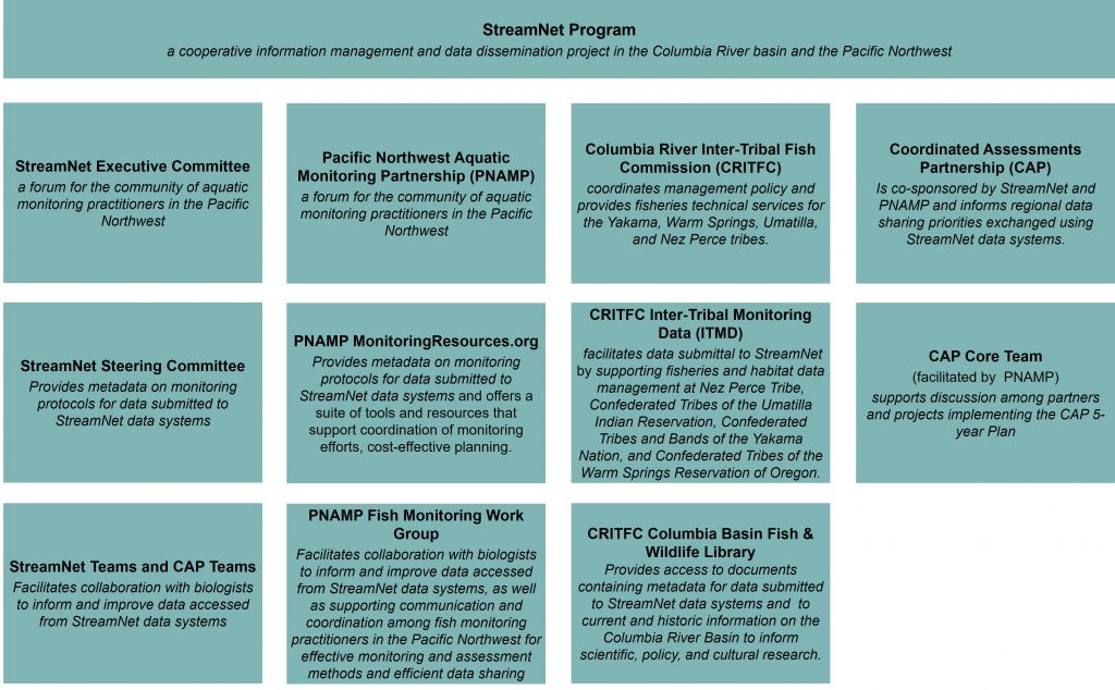
Coordinated Assessments Partnership (CAP) is a collaborative process to efficiently share fish information within the Pacific Northwest by providing access to standardized high level indicators (HLIs) needed for reporting and decision-making by natural resource managers and regulators. The information shared represents the partners' best available science.
CAP is co-sponsored by PNAMP and the StreamNet Program, with representatives from state and federal agencies, tribes, and tribal consortia who ensure data quality and flow to StreamNet. The Columbia Basin Fish and Wildlife Authority was a co-sponsor from 2009 until it was disbanded in 2014.
StreamNet continues its effort to expand its steering committee membership to agencies and tribes managing fish data and to initiate work on other priority regional data needs by expanding its geographic scope and data categories.
Current efforts are focused on regional needs of BPA, NOAA, NPCC, and the USFWS. To this end StreamNet, through CAP, also continues to seek opportunities to expand CAP high level indicators.
Sources
Allen, Stan. 2000. A Brief History of the StreamNet Project. Pacific States Marine Fisheries Commission.
StreamNet. 2020. 2019 StreamNet Annual Progress Report for January 2019 to December 2019. Bonneville Power Administration, Project 1988-108-04.

Vision
Support regional fisheries management and fish population status assessments and decision-making processes by making scientifically sound, standardized data accessible.
Mission
Coordinate and support efforts of state, tribal, and federal agencies to collect, manage, and share fish and aquatic habitat information in the Pacific Northwest, with an emphasis on the Columbia River Basin, to support public understanding and wise decision-making.
Background
StreamNet originated in 1995 through the consolidation of two projects funded since the 1980s by the Bonneville Power Administration (BPA): the Coordinated Information System and the Northwest Environmental Database. These were the first regional forums for standardized fish and aquatic habitat information to inform Columbia River Basin assessments, reports, and decision-making processes. Today, StreamNet supports sharing of fish population health indicators in the Pacific Northwest by co-sponsoring the Coordinated Assessments Partnership. StreamNet also serves as BPA’s system of record for fish distribution and facilities, providing a comprehensive location for partners’ information.
StreamNet reports to and implements the direction of the StreamNet Executive Committee, in a manner that is consistent with measures in the Northwest Power and Conservation Council’s (NPCC) Columbia River Basin Fish and Wildlife Program (FW-Program) and guidance from state, tribal, and federal fish and wildlife management plans, including federal Endangered Species Act recovery plans and biological opinions. StreamNet is funded by BPA as part of the FW-Program.
The data managed by StreamNet support regional decision-making, and NOAA Fisheries’ status reviews, NPCC’s FW-Program tools, and BPA’s tools and reports.
What We Do
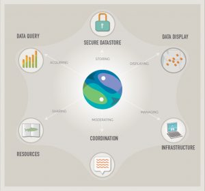
StreamNet utilizes state-of-the-art database and GIS technology to compile and maintain aquatic resource data.
StreamNet-funded staff provide significant technical database, GIS, and data transfer support services to state and tribal fish and wildlife agencies.
StreamNet staff support access to data through tables, GIS layers, charts, graphs, maps, and as the entire database in Microsoft Access format. Data may also be accessed as custom products prepared by StreamNet staff.
StreamNet also prepares custom GIS maps, graphs, and data reports for use by those involved in the protection, management, and restoration of the region’s aquatic resources.
StreamNet receives more than 1,500 requests for data and data services annually, and we routinely provide data and services to state and federal agencies, tribes, regional authorities, and private groups.
Regional Efforts & StreamNet
StreamNet relies on our partners and other regional efforts to help us achieve our mission and vision.
StreamNet collaborates with existing Columbia River Basin and other regional data management efforts to further enhance the flow of information needed to inform decision-making and reporting. These efforts are tasked with compiling information from a subset of the Basin, in some cases to support collaborative analysis. StreamNet works with these regional efforts to improve data-sharing access to information supporting regional high-level indicators and to improve associated metadata.
This coordination reduces the workload on individual biologists and data stewards by not requiring them to resubmit the same information into multiple data systems.

